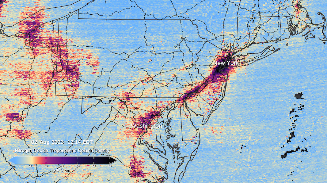
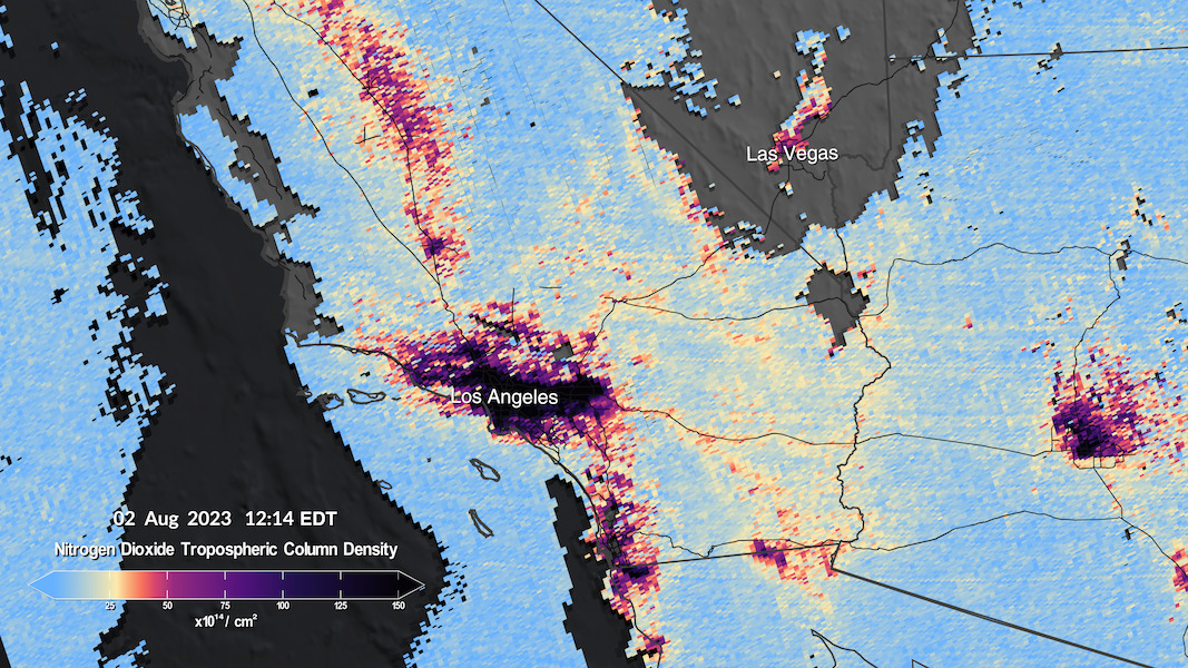
NASA recently released the first images from the Tropospheric Emissions: Monitoring of Pollution (TEMPO) instrument, which was launched to space earlier this year. The images show nitrogen dioxide pollution over North America. They provide a valuable tool for understanding and tracking air pollution.
TEMPO is a small satellite that was launched into orbit in March 2023. It carries a sensor that can measure nitrogen dioxide gas, a major component of air pollution. The sensor is sensitive enough to measure nitrogen dioxide concentrations at Earth’s surface. It can also measure how the pollution is transported by the atmosphere.
What Do NASA’s Air Pollution Images Show?
The first images from TEMPO show nitrogen dioxide pollution over the United States, Canada, and Mexico. The images reveal high levels of pollution in urban areas such as Los Angeles and Chicago. They also show how pollution is transported by the wind, with plumes of pollution extending hundreds of miles from their source.
The images from TEMPO are a valuable new tool for understanding and tracking air pollution. We can use them to identify areas with high levels of pollution, and to track how pollution changes over time. This information is helpful for improving air quality and protecting public health.
From its geostationary orbit, TEMPO continuously observes daytime pollution over North America.
This visualization shows six scans of air pollution over several major cities and transportation thoroughfares from about 11am to 5:30pm ET on Aug. 2, 2023. https://t.co/IzRJJXLmFu pic.twitter.com/BgX4yBFNih
— NASA Earth (@NASAEarth) August 24, 2023
The TEMPO mission is a joint project between NASA and the U.S. National Oceanic and Atmospheric Administration (NOAA). The mission is expected to last for five years, providing scientists with a wealth of data about air pollution.
The images from TEMPO are a reminder of the serious problem of air pollution. However, they also show that we have the tools to measure and track pollution, and we can use this information to make a difference.
How the TEMPO Images Impact Indoor Air Quality
The images from TEMPO identify areas with high levels of nitrogen dioxide pollution. This information is useful to help people avoid those areas or take steps to improve the air quality in their homes. For example, people who live in areas with high levels of nitrogen dioxide pollution may want to open their windows less often, use air purifiers, or plant trees around their homes.
The TEMPO images also track how nitrogen dioxide pollution changes over time. This information can be used to identify trends in air pollution and develop strategies to improve air quality.
Overall, the TEMPO images are a valuable new tool for understanding and tracking air pollution. They are a key step in improving air quality and safeguarding public health. They also help inform people on how to manage their indoor air quality.
Make sure to include @ the researchers, nasa and related agencies for twitter and instagram.
Learn more from NASA:
Image and Video Credits:
NASA’s Scientific Visualization Studio. Data provided by the Smithsonian Astrophysical Observatory at the Center for Astrophysics | Harvard & Smithsonian.